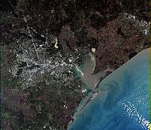
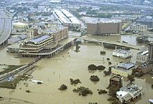
According to the United States Census Bureau, the city has a total area of 601.7 square miles (1,558 km2); this comprises 579.4 square miles (1,501 km2) of land and 22.3 square miles (58 km2) of water. Most of Houston is located on the gulf coastal plain, and its vegetation is classified as temperate grassland and forest. Much of the city was built on forested land, marshes, swamp, or prairie, which are all still visible in surrounding areas. Flatness of the local terrain, when combined with urban sprawl, has made flooding a recurring problem for the city. Downtown stands about 50 feet (15 m) above sea level, and the highest point in far northwest Houston is about 125 feet (38 m) in elevation. The city once relied on groundwater for its needs, but land subsidence forced the city to turn to ground-level water sources such as Lake Houston and Lake Conroe.
Houston has four major bayous passing through the city. Buffalo Bayou runs through downtown and the Houston Ship Channel, and has three tributaries: White Oak Bayou, which runs through the Heights neighborhood north of downtown and then towards downtown; Braes Bayou, which runs along the Texas Medical Center; and Sims Bayou, which runs through the south of Houston and downtown Houston. The ship channel continues past Galveston and then into the Gulf of Mexico.
Geology
Underpinning Houston's land surface are unconsolidated clays, clay shales, and poorly cemented sands up to several miles deep. The region's geology developed from river deposits formed from the erosion of the Rocky Mountains. These sediments consist of a series of sands and clays deposited on decaying organic matter, that over time, transformed into oil and natural gas. Beneath the layers of sediment is a water-deposited layer of halite, a rock salt. The porous layers were compressed over time and forced upward. As it pushed upward, the salt dragged surrounding sediments into salt dome formations, often trapping oil and gas that seeped from the surrounding porous sands. The thick, rich, sometimes black, surface soil is suitable for rice farming in suburban outskirts where the city continues to grow.
The Houston area has over 150 active faults (estimated to be 300 active faults) with an aggregate length of up to 310 miles (500 km), including the Long Point-Eureka Heights Fault System which runs through the center of the city. There have been no significant historically recorded earthquakes in Houston, but researchers do not discount the possibility of such quakes occurring in the deeper past, nor in the future. Land in some communities southeast of Houston is sinking because water has been pumped out from the ground for many years. It may be associated with slip along faults; however, the slippage is slow and not considered an earthquake, where stationary faults must slip suddenly enough to create seismic waves. These faults also tend to move at a smooth rate in what is termed "fault creep", which further reduces the risk of an earthquake.
Climate
Houston's climate is classified as humid subtropical (Cfa in Köppen climate classification system). Spring supercell thunderstorms sometimes bring tornadoes to the area. Prevailing winds are from the south and southeast during most of the year, bringing heat across the continent from the deserts of Mexico and moisture from the Gulf of Mexico.
During the summer months, it is common for the temperature to reach over 90 °F (32 °C), with an average of 99 days per year above 90 °F (32 °C). However, the humidity results in a heat index higher than the actual temperature. Summer mornings average over 90 percent relative humidity and approximately 60 percent in the afternoon. Winds are often light in the summer and offer little relief, except near the immediate coast. To cope with the heat, people use air conditioning in nearly every vehicle and building in the city; in 1980 Houston was described as the "most air-conditioned place on earth". Scattered afternoon thunderstorms are common in the summer. The hottest temperature ever recorded in Houston was 109 °F (43 °C) on September 4, 2000.
Winters in Houston are fairly temperate. The average high in January, the coldest month, is 62 °F (17 °C), while the average low is 39 °F (4 °C). Snowfall is generally rare. Recent snow events in Houston include a storm on December 24, 2004 when one inch (2.5 cm) fell and more recent snowfalls on December 10, 2008. However, more recently on December 4, 2009 an inch of snow fell in the city. This was the earliest snowfall ever recorded in Houston. In addition, it set another milestone marking the first time in recorded history that snowfall has occurred on two consecutive years, and marks the third accumulating snowfall occurring in the decade of 2000–2010. The coldest temperature ever recorded in Houston was 5 °F (−15 °C) on January 23, 1940. Houston receives a high amount of rainfall annually, averaging about 54 inches a year. These rains tend to cause floods over portions of the city.
Houston has excessive ozone levels and is ranked among the most ozone-polluted cities in the United States. Ground-level ozone, or smog, is Houston’s predominant air pollution problem, with the American Lung Association rating the metropolitan area's ozone level as the 6th worst in the United States in 2006. The industries located along the ship channel are a major cause of the city's air pollution.
No comments:
Post a Comment